Chewacla State Park in Auburn, Alabama features more than 25 miles of mountain bike and hiking trails built and maintained by CAMP volunteers. The system offers scenic singletrack for riders and hikers of all skill levels, all centered around one of the park’s most iconic features—the Chewacla waterfall.
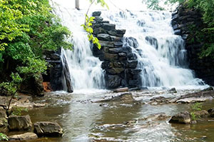
To reach the Chewacla waterfall, start from any of the main parking areas on the right side of the road and follow the Lakeside Connector Trail along the lakeshore, keeping the lake on your left. This scenic route leads directly to the dam and waterfall area, one of the park’s most popular destinations. The waterfall is easily accessible by bike or on foot and makes a great stop to take photos or enjoy the view.
E-bike Usage at Chewacla State Park
Pedal-assist (Class 1) e-bikes are allowed where traditional bikes are permitted. E-bikes with a throttle are not allowed. See Alabama State Parks Rules and Regulations for more information. CAMP follows and supports the policies set by each land manager where we build and maintain trails.
New to the trails? Check out our FAQ page for helpful tips and information before you go.
Chewacla State Park Trail Map
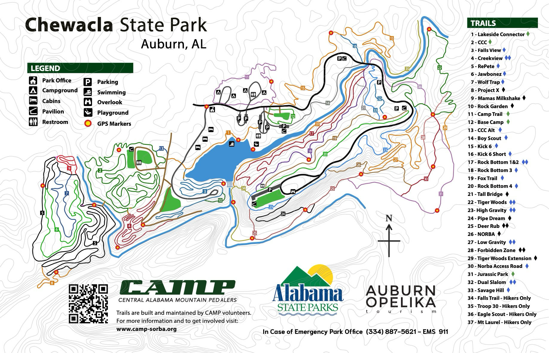
Chewacla State Park trail map (PDF)
CAMP volunteers build and maintain every mile of trail, with support from memberships and donations from riders and outdoor enthusiasts like you. CAMP does not receive any funding from state park gate fees.
Additionally, Alabama State Parks, including Chewacla State Park, receive very little tax payer support and rely on self-generated visitor revenue rather than direct appropriations from the state’s General Fund. To cover operational costs, the parks depend heavily on gate entry, camping fees, lodge rentals and partners like CAMP.
Want to see what the trails are like before you ride or hike? Browse our YouTube channel to explore virtual rides featuring some of the best routes in the park.
Chewacla State Park charges entrance fees:
- Ages 12–61: $5
- Ages 4–11: $3
- Ages 62+: $3
- Under 4: Free
- Active and retired military (with ID): Free
Annual passes are available at the gate.

Mountain Biking at Chewacla State Park
Chewacla is the premier mountain biking destination in Auburn, Alabama, with miles of volunteer-built singletrack.
CAMP Trail (1.0 mile)
This flat loop circles the campground with wide turns and minimal elevation change. It’s perfect for beginners or casual riders. More experienced riders often use it as a warm-up.
CAMP Trail
At just one mile, CAMP is a fun, beginner-friendly loop that doubles as a favorite warm-up ride for cyclists of all abilities.
CCC Trail (3.0 miles)
The trail begins after crossing the bridge from Creek View. Riders can take a short advanced option or bypass it using the CCC connector. From there, the trail follows a historic CCC route near the old camp, now the group campground.
The trail winds through forest and along Town Creek, passing remnants of the CCC era. It then climbs past the old water tower before returning to the Lakeside Connector.
CCC Trail
At 2 miles, CCC Trail features short climbs and winding turns, offering a gentle challenge while remaining beginner-friendly. It’s a fun next step for riders ready to move beyond CAMP.
Lakeside Connector Trail (.5 miles)
This connector links Falls View, Creek View, CCC, and RePete. Beginning on Ranger Dell’s Trail, it winds downhill through the glen near the paddle boat area. With the lake on your left, the trail guides you toward the Chewacla waterfall, formed by a dam built by CCC workers in the 1930s.
The trail then follows the lakeshore, passes between cabins and the lake, and crosses the paved road. Riders can turn left to access Falls View or continue straight to CCC.
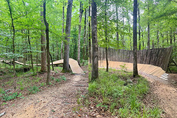
Ranger Dell’s Trail (0.6 miles)
Dive into the singletrack right behind the ranger station. This fast, flowing trail snakes through a dense glen and serves up a fun creek crossing over Scorpion Bridge. The gentle, rolling terrain is the perfect playground for building your foundational handling skills. Ready for more? The trail features The Great Wall, a progression zone where beginners and advanced riders alike can choose their own line and test their limits.
The trail begins and ends near the beach pavilion and offers a great introduction to longer trails.
Falls View Trail (1.0 mile)
This trail follows the lake before climbing toward the dam and waterfalls. It features roots, rocks, and tight turns along the bluff.
Riders will encounter dips, a short optional climb, and a log jump before finishing high above the creek.
The Rock Gym (Falls View alternate feature)
This short but technical section branches off Falls View after the log-over. It drops into a boulder garden with multiple line choices.
Options range from rollable lines to 3–4 foot drops. A wooden feature offers an alternate exit. Riders climb back up to rejoin Falls View.
Creek View Trail (1.3 miles)
The trail begins with a ramp onto a banked boardwalk around Volkswagen Rock. It then follows a historic CCC-built route along the creek.
Riders pass rock walls and scenic water views before climbing the bluff on flowing berms. The trail continues through rock gardens and boulders before descending to a bridge that connects to CCC.
Hank/Graham Bridge
Not a trail per se but worthy of note. The bridge is 92’ long, 8’ wide, and 10’ higher than the normal creek level. It is built to be 3’ higher than the water level achieved during a hundred-year flood. Created by a number of volunteers with the majority of muscle and brain power supplied by Hank Albritton, Graham Yuill, Austin Yuill, and Darrel Hankerson. The only motored machine used was John Deere Gator 4WD ATV. The first set of poles was dragged down to the creek using only manual labor, Austin’s lifting device, and ropes. Everything else was done with brute force and tools built by Austin or supplied by or purchased by Graham and Hank. Telephone poles were donated by Alabama Power and lumber by Spencer Lumber.
It stands as one of CAMP’s most impressive volunteer-built structures.
RePete (6.5 miles)
RePete starts with a climb off the bridge and continues through rolling terrain, rock gardens, and forest sections.
The trail mixes flow, technical features, and narrow bridges. Riders will encounter climbs, descents, and loose terrain throughout.
Project-X (0.3 miles)
This hand-built trail branches off RePete. It begins with a steep descent featuring small drops and jumps.
After a fast downhill and short climb, riders cross two rocky stream sections before tackling a steep climb back to RePete.
Mama’s Milkshake (0.3 miles)
This trail drops off the plateau with berms and jumps before reaching a large rock drop. Riders can avoid the drop by staying high right.
After the drop, the trail climbs steeply before finishing with a fun descent through a deep gully.
Kick Six (1.5 miles)
Kick Six connects to the upper trail system and includes features like the Roller Bridge and Hero Wall.
The trail starts near the dirt jumps, crosses John’s Creek, and flows through rolling terrain. Riders can choose a shortcut or continue to the Hero Wall before descending back toward the creek.
Kick 6
Kick Six mixes flow, bridges, rock gardens, and creekside features for riders ready to step into intermediate terrain.
Rock Bottom (3.5 miles)
Rock Bottom features four distinct lines, each offering a different experience.
- Line 1: Most technical, with heavy rock features
- Line 2: Includes gravity sections and alternate lines
- Line 3: Fast and smooth, with an optional gap jump
- Line 4: Parallels the road and connects to Twin Pines Dual Slalom
Riders often ride this trail in both directions for different challenges.
Rock Bottom
With twists, challenges, and plenty of character, Rock Bottom is best ridden both ways. Each direction offers a fresh experience
Sweet Shrub Trail (0.4 miles)
This moderate trail follows Moore’s Mill Creek and connects the lower and upper trail systems.
It includes a quick descent, a small bridge, and a rock garden before ending at the stone bridge.
NORBA National Trail (0.4 miles)
Also available is the historic NORBA National Trail, where mountain biking legends like Ned Overender and John Tomac raced in 1988. This race was the very first NORBA National race east of the Mississippi River, making the NORBA National Trail an important piece of south eastern mountain biking history.
This section offers users two different experiences. In the up direction, this is the longest sustained climb in the park and offers a good return from Pipe Dream and Deer Rub trails. In the downhill direction the narrow tread width and tight trees offer a fast and fun downhill experience.
Twin Pines Dual Slalom (0.15 miles)
This 0.15 mile race course is built in to Line 4 of rock bottom. This short race course features berms, rhythm sections, and jumps. It’s smooth, fast, and ideal for practicing skills or racing friends.
Fox Trail (0.8 miles)
Originally built for hiking, this trail provides an easier route to the top. A fork midway leads either to the summit or the middle pavilion.
High Gravity (1.1 miles)
This trail begins near the overlook and passes the Quarry Overlook, the park’s highest point.
It includes optional features, rolling terrain, and three downhill segments separated by short climbs. Best ridden downhill.
Low Gravity (1.1 miles)
Low Gravity connects NORBA Double Track to High Gravity. It features winding climbs, flowing descents, and small features like rollers and jumps.
Tiger Woods (1.3 miles)
This trail loops from the NORBA Double Track and descends toward the creek before climbing back out.
It includes berms, drops and rock features packed into a short distance.
Tiger Woods Extension
This advanced trail continues from Tiger Woods with a wooden feature includes a steep waterfall drop. Ride with caution.
Pipe Dream (0.5 miles)
This downhill-only trail runs from the Quarry Overlook to the creek.
It includes jumps, rock features, and the “Leap of Faith,” a 3-foot drop. Riders should scout the trail before riding.
Deer Rub (0.6 miles)
This is a multi-use trail at Chewacla State Park that drops off the top of the mountain from behind the upper pavilion. While this is a popular hiking trail, it offers mountain bikers a uniquely challenging steep downhill culminated in a mandatory 4′ drop off of a buried log.
Keep your speed in check and look out for other trail users as this is a popular hiking trail. The lower part of deer rub is also used as a return for Pipe Dream.
This trail is too steep to ride up from the bottom so it is best used as a DH only trail for bikes. Hikers use this trail in both directions.
Forbidden Zone (0.3 miles)
This trail features a large number of man-made free-ride features, including dirt and wood jumps, a qualifier skinny, step downs, hips, transitions, and other features. This trail starts on the Tiger Woods trail near the top of the berms, and continues downhill, crossing the access road via multiple paths, including a 33 foot road gap and a step down bridge.
It is highly recommended that you scout the whole line first before you drop in, as there are numerous large features here. Pre-ride, re-ride, and free-ride!